 Sample Bot
Liberty County postal map
Every ER:LC postal on the Liberty County map, with the road it is on. Type a postal number to see where it is. There are 147 postals, numbered 200 to 9901, and the same ones show up in the Sample CAD.
Pick a postal below, or type one.
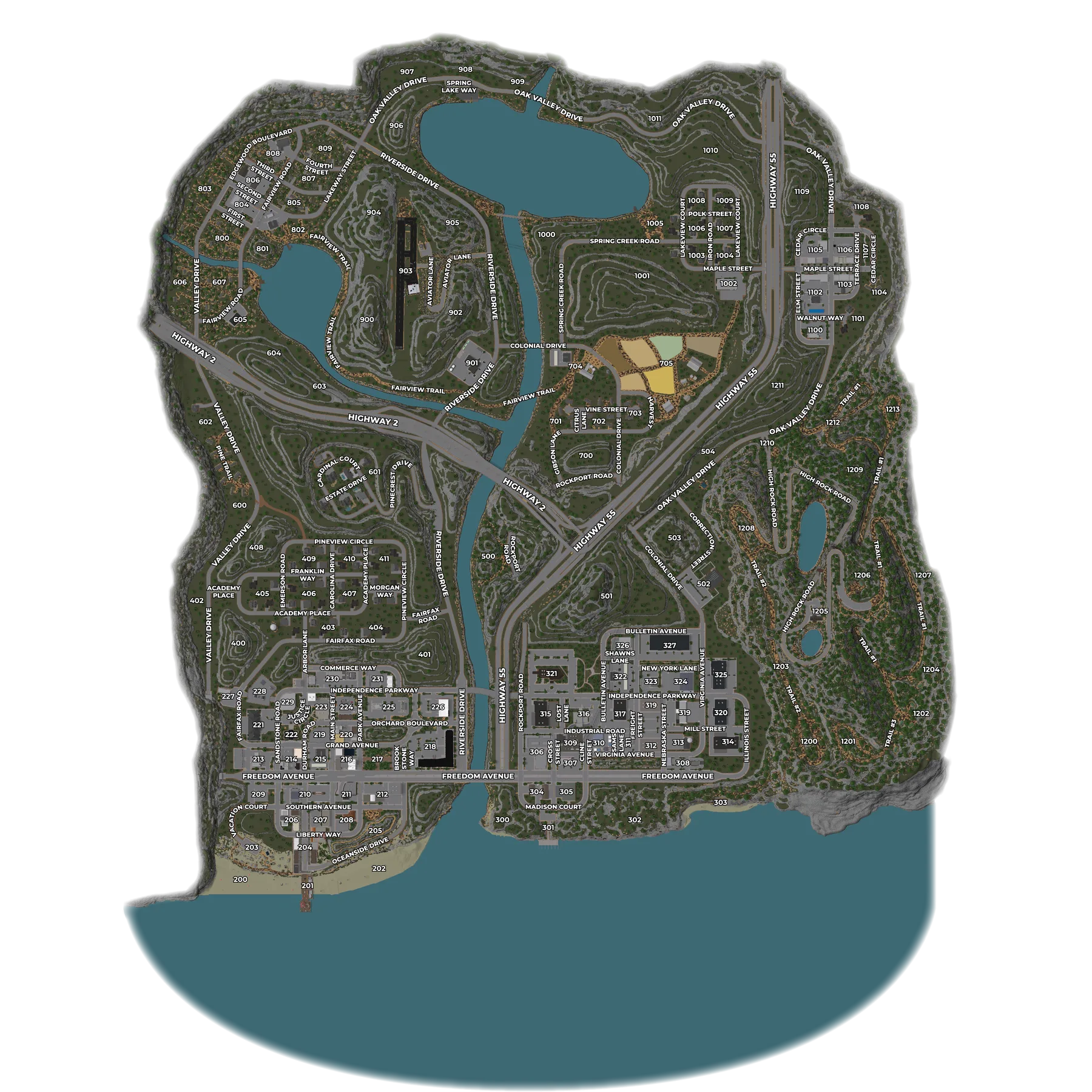
All postals and their streets
The street is the nearest named road to the middle of that postal, so use it to find your way. In the Sample CAD, every call and every unit shows its postal, and AI dispatch reads it out.
| Postal | Nearest road |
|---|---|
| 200 | Vacation Court |
| 201 | Main Street |
| 202 | Oceanside Drive |
| 203 | Vacation Court |
| 204 | Main Street |
| 205 | Oceanside Drive |
| 206 | Liberty Way |
| 207 | Liberty Way |
| 208 | Liberty Way |
| 209 | Southern Avenue |
| 210 | Southern Avenue |
| 211 | Main Street |
| 212 | Freedom Avenue |
| 213 | Fairfax Road |
| 214 | Sandstone Road |
| 215 | Durham Road |
| 216 | Grand Avenue |
| 217 | Grand Avenue |
| 218 | Freedom Avenue |
| 219 | Durham Road |
| 220 | Grand Avenue |
| 221 | Fairfax Road |
| 222 | Orchard Boulevard |
| 223 | Orchard Boulevard |
| 224 | Main Street |
| 225 | Orchard Boulevard |
| 226 | Independence Parkway |
| 227 | Fairfax Road |
| 228 | Independence Parkway |
| 229 | Independence Parkway |
| 230 | Commerce Way |
| 231 | Commerce Way |
| 300 | Cline Street |
| 301 | Cline Street |
| 302 | Cline Street |
| 303 | Independence Parkway |
| 304 | Cross Street |
| 305 | Cline Street |
| 306 | Cross Street |
| 307 | Virginia Avenue |
| 308 | Virginia Avenue |
| 309 | Industrial Road |
| 310 | Industrial Road |
| 311 | Sams Lane |
| 312 | Virginia Avenue |
| 313 | Nebraska Street |
| 314 | Mill Street |
| 315 | Industrial Road |
| 316 | Industrial Road |
| 317 | Bulletin Avenue |
| 318 | Independence Parkway |
| 319 | Virginia Avenue |
| 320 | Mill Street |
| 321 | Independence Parkway |
| 322 | Bulletin Avenue |
| 323 | New York Lane |
| 324 | Independence Parkway |
| 325 | Bulletin Avenue |
| 326 | Bulletin Avenue |
| 327 | Bulletin Avenue |
| 400 | Fairfax Road |
| 401 | Fairfax Road |
| 402 | Valley Drive |
| 403 | Fairfax Road |
| 404 | Fairfax Road |
| 405 | Academy Place |
| 406 | Academy Place |
| 407 | Carolina Drive |
| 408 | Pineview Circle |
| 409 | Franklin Way |
| 410 | Carolina Drive |
| 411 | Pineview Circle |
| 500 | Highway 2 |
| 501 | Bulletin Avenue |
| 502 | Colonial Drive |
| 503 | Correction Street |
| 504 | Oak Valley Drive |
| 600 | Pine Trail |
| 601 | Estate Drive |
| 602 | Valley Drive |
| 603 | Highway 2 |
| 604 | Highway 2 |
| 605 | Fairview Road |
| 606 | Edgewood Boulevard |
| 607 | Fairview Road |
| 700 | Gibson Lane |
| 701 | Gibson Lane |
| 702 | Gibson Lane |
| 703 | Vine Street |
| 704 | Colonial Drive |
| 705 | Harvest Drive |
| 800 | Fairview Road |
| 801 | Fairview Road |
| 802 | Second Street |
| 803 | Edgewood Boulevard |
| 804 | First Street |
| 805 | Second Street |
| 806 | Third Street |
| 807 | Fourth Street |
| 808 | Fairview Road |
| 809 | Edgewood Boulevard |
| 900 | Fairview Trail |
| 902 | Aviator Lane |
| 903 | Aviator Lane |
| 904 | Lakeway Street |
| 905 | Riverside Drive |
| 906 | Oak Valley Drive |
| 907 | Oak Valley Drive |
| 908 | Spring Lake Way |
| 909 | Oak Valley Drive |
| 1000 | Spring Creek Road |
| 1001 | Spring Creek Road |
| 1002 | Maple Street |
| 1003 | Spring Creek Road |
| 1004 | Iron Road |
| 1005 | Spring Creek Road |
| 1006 | Lakeview Court |
| 1007 | Iron Road |
| 1008 | Polk Street |
| 1009 | Iron Road |
| 1010 | Lakeview Court |
| 1011 | Oak Valley Drive |
| 1100 | Oak Valley Drive |
| 1101 | Walnut Way |
| 1102 | Elm Street |
| 1103 | Terrace Drive |
| 1104 | Cedar Circle |
| 1105 | Cedar Circle |
| 1106 | Oak Valley Drive |
| 1107 | Terrace Drive |
| 1108 | Cedar Circle |
| 1109 | Oak Valley Drive |
| 1200 | Trail #3 |
| 1201 | Trail #3 |
| 1202 | Trail #3 |
| 1203 | Trail #2 |
| 1204 | Trail #1 |
| 1205 | High Rock Road |
| 1206 | High Rock Road |
| 1207 | Trail #1 |
| 1208 | Trail #2 |
| 1209 | Trail #1 |
| 1210 | Oak Valley Drive |
| 1211 | Oak Valley Drive |
| 1212 | Trail #1 |
| 1213 | Trail #1 |
| 9901 | Riverside Drive |
What is a postal in ER:LC?
A postal is a numbered zone on the Liberty County map. Roleplayers say “postal 218” to say where a call, a traffic stop or a scene is, the way people use street addresses. ER:LC shows your postal in the game, and a CAD uses the same numbers.
How do I find a postal on the ER:LC map?
Type the number into the box at the top of this page and the map marks it, along with the road it is on. You can also search by street name to see which postals it runs through.
Where do the postals come from?
The postal numbers and road names come from the Liberty County map data the Sample CAD uses, so they match what dispatchers and units see on the live map. Want that map for your own server? See the ER:LC CAD guide.